
How do you get from point A to point B on a ginormous, constantly moving, and completely unmarked body of water once you lose sight of land? And, oh, by the way, it’s the 1400s… so no GPS, no Wi-Fi, and no Mini-Mart with maps and snacks. Bummer.Very, very, very early navigators faced serious dangers on their quest to explore new lands or search for riches, and—hopefully—find their way back home. Even the best navigation plans could be waylaid if the crew didn’t have knowledge of winds and currents.In these early times, sailors used “coasting” to keep land in sight throughout the journey, but that didn’t work on the open sea. Many relied on “dead reckoning”: estimating each new position based on the ship’s previous position, speed, and direction. But this was prone to error, especially on long voyages.
Navigation is based on latitude and longitude. (https://journeynorth.org/tm/LongitudeIntro.html). While latitude could be determined with basic instruments, dead reckoning, or educated guesses, longitude required comparing local time, measured by a heavenly body, with the local time at a reference location, kept by a clock, which, today, is at British Royal Observatory in Greenwich England.
Each voyage shed new knowledge on how to harness longitude and latitude to map the sea. Navigation methods improved over time with a big boost from technology. But it took some mighty brave explorers and plenty of ingenious thinking to bring together natural resources like the sun, moon, wind, and stars with manmade gadgets to make navigation safer and more accurate. Check out some of the cool innovations that brought us to modern-day navigation.
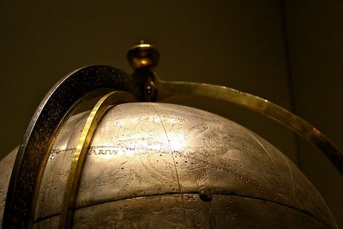
Celestial Globe
An early navigation tool, the Celestial Globe, depicted the apparent position of stars just as the globes we are familiar with tell us where everything is on the planet earth. The earliest known Celestial Globe is the Farnese Globe created in the 3rd Century BCE. It is on display at the National Archaeological Museum in Naples, Italy.
Cross-staff
Also known as a fore-staff or Jacob’s staff, the cross-staff measured the angle between the horizon and a heavenly body like the sun or the stars. It was used to determine latitude and direction. The original idea for this tool may date back to ancient Mesopotamians in 400 BCE.
Log Line
A log line was a piece of wood, weighted at one end and attached to a rope with knots tied at six-foot (one fathom) intervals. The rope was attached to a spool and was rolled out as the ship moved forward so sailors could measure the distance traveled. The water resistance kept the weighted wood stationary.
Astrolabe
The astrolabe actually had thousands of applications, but the sea astrolabe was used for determining the latitude by measuring the altitude of the sun at midday or the meridian altitude of a star. The disc has pieces cut out to reduce wind resistance and keep it steady.
Traverse Board
The Traverse Board enabled mariners to record and remember measurements. The board had a compass rose with eight holes extending out to each compass point representing 30-minute timeframes for the four hours that a sailor was on watch. Small wooden pegs would be placed in the holes every half hour in the direction the ship was sailing. Other holes on the bottom were used to measure the ship’s speed.
Learn More